I have a keen interest in cities and the urbanisation process. I can trace this interest to my experiences growing up in an apartheid era black township. I feel this has increased my awareness of the challenges of housing, economic development, and the lack of social integration my home in Soweto has with the rest of Johannesburg.

I am driven by explorations of urban settlements through questions of identity, sustainability and equality. My passion for architecture is focussed these aspects of spatial transformation and design.


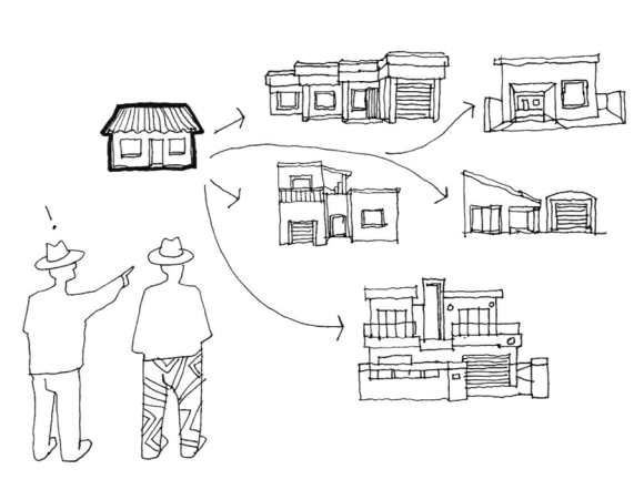
(Images: Author Mixed)

This journey has led me to pursuing a PhD at the Tshwane University of Technology under Dr. Amira Osman. I’d like to share the early framing of this project with you here in this article. This project is currently titled:
The Center, the In-Between and the Periphery: Harnessing the Potential Of Inclusive Urbanism towards the Defragmentation of Johannesburg in Africa
The dissertation seeks to interrogate the existing spatial realities of Johannesburg as it was shaped by colonialism and how it may evolve in the future. The intention of the study is to address the fragmentation and segregation caused by the inherited spatial structures of the Apartheid and colonial city.

The planning of colonial cities, especially Johannesburg was based on achieving maximum control. The urban morphology was many times based on policies that organised people through race, class, and ethnicity. Johannesburg in South Africa, is a major urban centre in the Southern Region in Africa with increasing economic and spatial inequality.
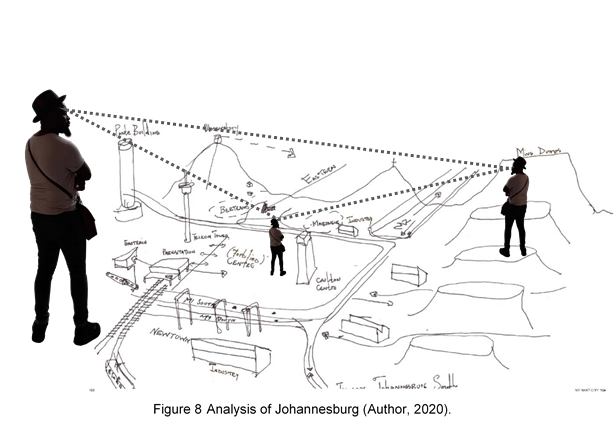
The urban morphology of Johannesburg will be studied with a comparison analysis with other African cities which have similar patterns of spatial fragmentation in urban form due to colonial powers. The aim is to observe, compare and propose a defragmentation process towards the transformation of Johannesburg.

This will be done by studying the existing conditions and adopted strategies towards housing, employment opportunities, transport and public space. The inherited spatial realities are still evident today; these structural realities are restrictive, unsustainable, and disadvantage communities ecologically, economically and socially.


The thesis is premised on an understanding that economic inequality is related to spatial inequality. It will look at the various challenges faced by Johannesburg in relation to other cities in Africa based in the centre, the in-between and the periphery in terms of systems of governance and policies. It will look into how they affect the diverse stakeholders of the built environment, those being government agencies, private sector, communities and individuals from a macro to micro level.
My Departure Point
During the Apartheid era, every major city and minor town received a lesser twin – a township – built to house non-white South Africans. The houses, ‘matchboxes’, was the basic building bock, a minimal dwelling, repeated with little variation, on cheap land at a distance to centres of employment, services and business. The townships were an integral part of the state’s strategy to keep black and non-white South Africans in a disadvantaged position socially and spatially.

The urban morphology of the city was engineered to separate, dislocate and fragment neighbourhoods into racial zones that feed the inner core/city centres especially in the case of Johannesburg. According to Demisse (2012:21) from its inception, colonialism pervaded all aspects of the built environment by forcibly removing native populations to racial and highly policed zones outside the city known as native locations or native towns which have issues with congestion, overcrowding and exploitation. The spatial limitations, physical barriers, narrow nodes and dormitory townships are remnants of apartheid planning and mining sector.

The model of the apartheid city according to Davis. (Image: R.J. Davis, 1981)
For people living in Soweto (short for South Western Township) far from the city centre as and still is, frustrating. The residents of Soweto have, and still do, face challenges towards accessing of adequate housing, economic development and social and spatial isolation and disconnection from the rest of the city. This fragmentation manifests differently in different parts of the city: the centre, the in-between and the periphery. Townships were rolled out as dormitory towns of non-white South Africans as the means to provide cheap labour for the city centre and neighbouring suburbs. The spatial planning of townships and its housing typology are one of the most visible and notorious remnants of the Apartheid era. The township houses informally known as matchbox were referred to as NE51/9 (non-European housing designed in 1951, version 9).
The matchbox was the basic building block, minimal dwelling divided into four rooms, repeated with little variation, on cheap land and at a distance to centres of employment, services and business. The small size and scale of the township houses meant limited personal space and a lack of privacy, which meant that children and adults alike spent much of their time in the streets. Morphet (1998:159) writes:
“South Africa under the pressure of apartheid lost the positive meanings of both modernism and regionalism. The designs and techniques of the international styles were put to work to fragment the population into culturally insulated locations and ‘homes’ from which they could not escape”.


Towards this, I was involved in TV series with Thorsten Deckler of 26.10 South Architects that took at how people had extended their ‘matchbox houses’. This show, Matchbox, looked at how people has take their Apartheid era housing unit and adapted, enhanced and created more room for their families and businesses. This experience alongside my career in practice led me to begin exploring and examining the infrastructural origins of these policies and how they not only affected people’s homes but the entire city.

This thesis aims to examine the inherited spatial realities of colonialism. Africa was partitioned off to different countries and the colonial powers had different influences in the different countries. In response to this – and drawing from contemporary literature on the topic – Huang (2016:64) (as cited in Lall, Henderson & Venables, 2017) maintains that:
“Nearly all African Cities look like collections of small neighborhoods. Outside the high-density city core of a stylized African city, infrastructure is poor, specialization is low and land has mix uses – often unregulated and informal. New satellite towns develop in the peri-urban areas, where land is cheaper. But because these new towns have few economic opportunities; lack social amenities (schools, markets); and are not well connected to the urban core, they do not become viable, supporting centers. Instead, they emerge as a secondary, disconnected neighborhoods. Large mushrooming informal settlements emerge along the axes of connectivity, usually major arterial roads or rivers and canals. On the outskirts, the city’s rural area see construction in pockets of private investments”.
Angel (2018:21) states that:
“We suspect that most urban planners and policymakers – at the local, national and international level – are not fully aware of the extent to which urban peripheries are growing and are unsure of the quality of the urban fabric in these new urban peripheries”
Lall et al (2017) state that:
“With cities physically dispersed, Africans in urban areas are disconnected from one another. Urban expansion has occurred as leapfrog patches – small parcels of newly built land that do not border, intersect or overlap on existing urban built up areas, leading to high transportation cost and lower access to markets and other people in the city. Within the urban core, population’s densities vary widely across locations, reducing the chances for the large sections of the population to interact with other groups in the city”.
Current researchers define three aspects of connected urban morphology: The Centre: (the CBD, suburbs, industrial node), the In-between: (the thresholds, buffers, gateways, mobility) and the Periphery: (the locations, the residence)
1.The Centre : (the CBD, suburbs, industrial node)
2.The In-between: ( the thresholds, buffers, gateways, mobility)
3.The Periphery: (the locations, the residence)
Addressing Spatial Defragmentation
From my early research it appears that Spatial Defragmentation can be characterised as:
“A system of boundaries (cordon sanitaire) and its supporting architecture was developed to reinforce the separation of the European towns from the “native towns”. Thus, walls, buffer zones and defensive architecture were incorporated in the planning of colonial cities as part of a wider spatial strategy to ensure surveillance and control over the African populations.”
Demissie (2012:3)
For now it appears that knowledge and literature on defragmentation is limited towards the practice of it. It can be closely related to integration and inclusive however it doesn’t explain the process defragmentation.
In order to integrate spatial fragments towards an inclusive environment we first have to defragment the structurally restrictive systems and physical forms that perpetuate pervasive living environments which create unequal societies. Towards this, the dissertation aims to propose a system of defragmentation of the inherited urban morphology of Johannesburg and support a process towards an inclusive and equitable urban environment.
It will address housing, economic nodes, transport mobility and public space by aiming the research focus of the spatial fragments in:
- A process of restructuring, reorganising and reshaping spatial fragments in order to provide inclusive public space, equitable living, learning and working spaces in close proximity to one another to reduce travel time and cost.
- The process removes physical barriers that discourage socio-economic and cultural inclusivity and exchange between different race, income and ethnic groups.
- The process and steps of defragmentation will be guided by understanding the characteristics of fragmentation at various urban scales; the center, the in-between and the periphery of the three cities.
The center, the in-between and the periphery.
The thesis proposes a:
- Spatial defragmentation process
- Conceptual urban design framework
Which could be adopted as a:
- A set of guidelines,
- Policy,
- Design toolkit
These could be possible outputs of the dissertation driven by the following research questions:

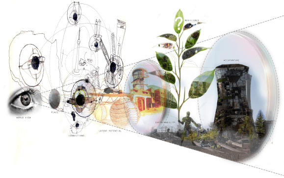
This study is based on the world view that:
- Socio-economic equity has not been achieved, and this remains as a challenge in city locations which emerged because of historical realities, policies and practices that have created spatial fragmentation and divisions.
- Spatial fragmentation is one of the major causes of economic inequality, social exclusion and increase in unemployment; which leads to higher poverty levels, conflicts and backlog in public services.
It is based on the historical realities of African cities, the spatial implications of the previous regimes, and believes this can be changed by bridging the fragments spatially for an increased economic equity, access to affordable housing, public space and employment opportunities.
Case Studies
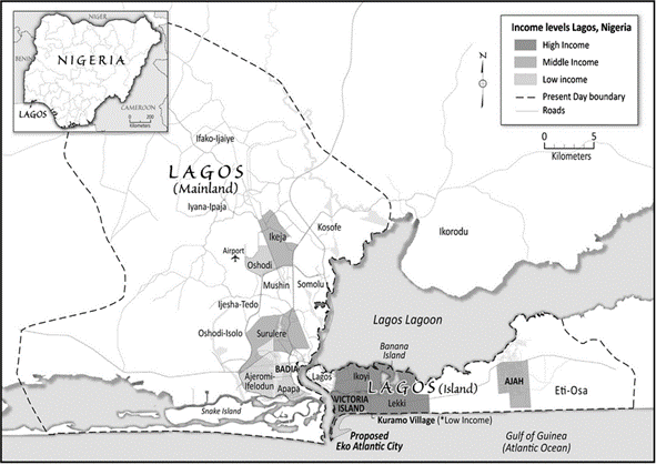
Three cities will be analysed: Cairo, Lagos and Johannesburg.
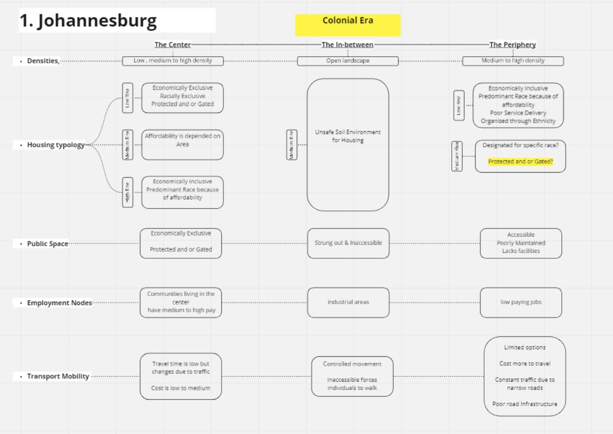
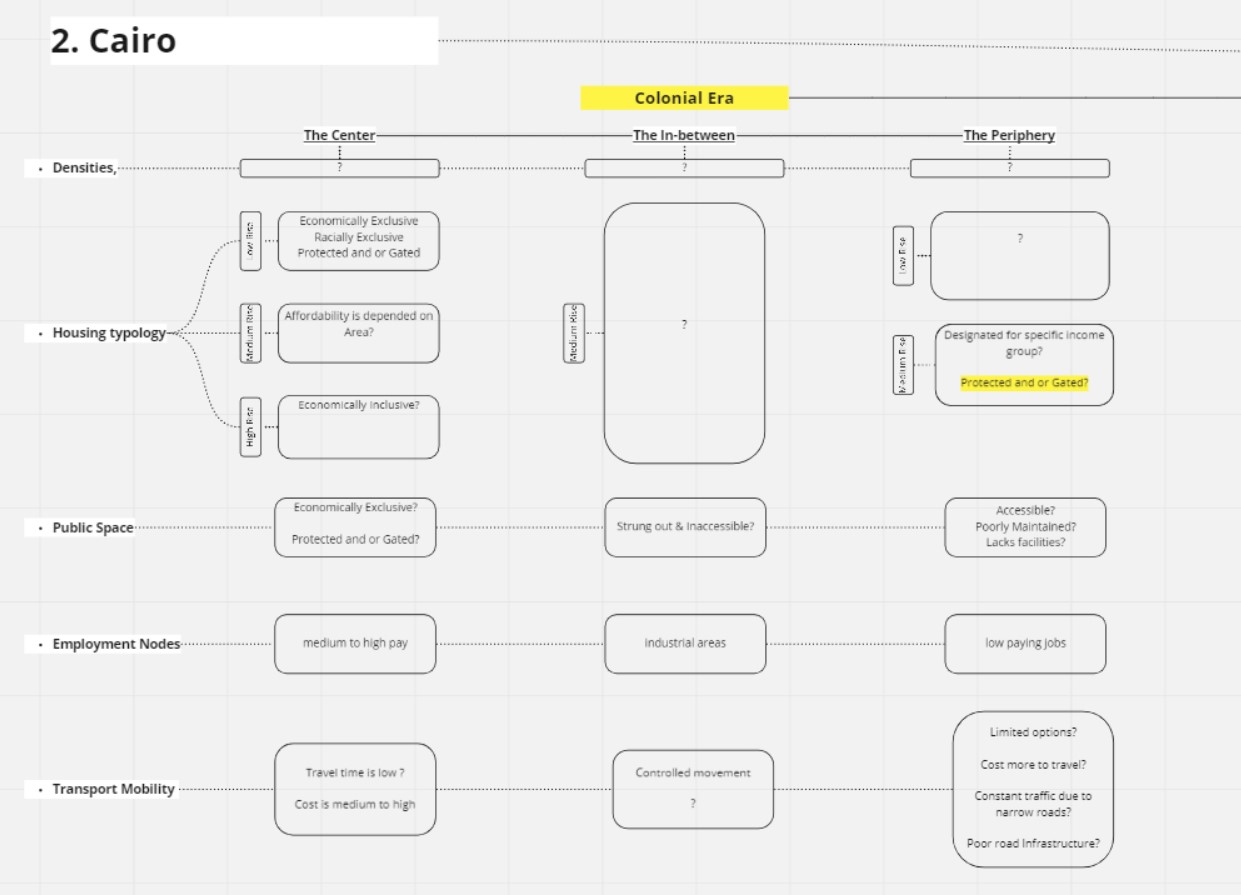

Comparative text and graphics will highlight the similarities and differences by specifically considering:
- Densities,
- Road networks,
- Gated communities,
- Informal settlements,
- Housing typologies,
- Public space,
- Employment nodes,
- Transport and mobility
The impact of the spatial realities on the residents of these cities will also be considered. This will be done by a comparative analysis of the three cities and will conduct a spatial analysis which adopts:
1.Transect walking as an observation and mapping methodology.
a. The observation and mapping is limited to a:
- Main node,
- Main street,
- A block,
These will be chosen at a Center, an In-between and a Periphery of each city.
2.Comparative study of existing data, and graphic maps of past, current, and future policies, guidelines and frameworks on spatial planning, place making and design
3.Literature Review
4.Graphic representation – translating data into easy-to-access visuals
5.A running/interactive exhibition
6.Interactive online platforms
Next Steps
In South Africa, it is easy to see how socio-economic inequality is directly proportional to spatial inequality. Living on the margins far from economic nodes perpetuates a culture of exclusion and inequality. The effects of fragmented urban morphology and social segregation so far is as fragmented, as the discourse.
Spatial and built environment agents and stakeholders such as the private sector, individuals and spatial practitioners should adopt inclusive urbanism policies in order to address the fragmentation in urban form. Equity and equality may be achieved by restructuring space in cities through investigation of scale, distance and time.
In order to provide inclusive urban form, a spatial defragmentation process should be implemented. It can be adopted as a conceptual urban design framework, guideline, a policy, and a design toolkit aimed at spatial fragments around housing, economic nodes, transport mobility and public space in the center, the in-between and the periphery.

This thesis aims to support this process and contribute this dimension of research to the greater body of contemporary knowledge production.
Excerpts taken from my published work available here.
References:
African Development Bank Group. 2018. Nigeria – Eko Atlantic City Development, Lagos, Nigeria – Shoreline Protection, Land Reclamation and City Masterplanning – ESIA Summary. [O]. Available from: https://www.afdb.org/en/documents/ document/nigeria-eko-atlantic-citydevelopment-lagos-nigeria-shorelineprotection-land-reclamation-and-citymasterplanning-esia-summary-106865. Accessed 16/07/2020.
Angel, Shlomo. 2018. New Urban Peripheries- Essays _Urban Age. LSE cities, p1. [O]. Available from: https://urbanage.lsecities. net/essays/new-urban-peripheries. Accessed 5/06/2020.
Badawy, Aya, Abdel-Salam, Hassan and Ayad, Hany. 2015. Investigating the impact of urban planning policies on urban division in Cairo, Egypt: The case of El-Maadi and Dar El-Salam. [O]. Available from: http:// http://www.elsvier.com/locate/aej, [Accessed 13/05/2020]. 172 ||
Baruah, Neeraj, Henderson, J Vernon and Peng, Cong. 2017. Colonial Legacies: Shaping African Cities. [O]. Available: http:// eprints.lse.ac.uk/86574/1/sercdp0226. pdf. Accessed: 13/05/2020.
Bremner, Lindsay. 1998-2008. Writing the City into Being: Essays on Johannesburg. Johannesburg: Fouthwall
Chipkin, Clive. 2008. Johannesburg Transition: Architecture & Society from the 1950. Johannesburg: STE Publishers.
Demissie, Fassil. 2012. Colonial Architecture and Urbanism in Africa, Intertwined and Contested Histories. London: Routledge.
Fang, Chuanglin and Yu, Danlin. 2017. Urban agglomeration: An evolving concept of an emerging phenomenon. [O]. Available from: http://www.elsevier.com/locate/ landurbanplan. Accessed 13/05/2020.
Graafland, Arie. 2012. African Perspectives- South Africa. City, Society, Space, Literature and Architecture. Rotterdam: 010 Publishers Haylett, Chris. 2003. Culture, Class and Urban Policy: Reconsidering Equality. 35:5573. [O]. Available from:https://doi. org/10.1111/1467-8330.00302. Accessed 17/06/2020.
Jimenez, Lai. 2012. Citizens of No Place: An Architectural Graphic Novel. New York: Princeton Architectural Press.
Khalifa, Marwa, Van Nes, Akkelies, Salheen, Mohamed and Hamhaber, Johannes. 2014. Understanding urban segregation in Cairo: The social and spatial logic of a fragmented city. [O]. Available from: http://www.researchgate.net/ publication/276285052. Accessed 20/05/2020.
Kreutzfeldt, Dorothee and Malcomess, Bettina. 2013. Johannesburg Not No Place. Johannesburg. Jacana Press.
Lall, Somik, Henderson, J Vernon and Venables, Anthony. 2017. African Cities: Opening Doors to the world. World Bank, Washington, DC. [O]. Available from: http://elibrary.worldbank.org/doi/ book/10.1596/978-1-4648-1044-2. Accessed 20/05/2020.
Lepofsky, Jonathan and Fraser, James. 2003. Building Community Citizens: Claiming the Right to Place-Making in the City: 127142. [O]. Available from: http://www. researchgate.net/publication. Accessed 26/05/2020. Mahmoud, Randa A and Rashed, R. 2016. New Cairo’s Urban Paradox: All-Inclusive Urbanism vs. Social Exclusion. SBE16Cairo. [O]. Available from:https://www. researchgate.net/publication/333798565. Accessed 18/07/2020.
Mbembe, Achille and Nutall, Sarah. 2007. The Elusive Metropolis. Johannesburg: Wits University Press. Moreno, Eduardo. 2018. Urbanisation Trends- Essays Urban Age. LSE cities, p1. [O]. Available from:https://urbanage.lsecities. net/essays/urbanisation-trends. Accessed on 20/06/2020. Morphet, Tony. 1998. “Personal Traits: The work of Eaton and Bierman in Durban”.
Blank Architecture, Apartheid and After, editado por Judin, H. & Vladislavic, I. Rotterdam: NAi Publishers 5:148-161. Mushongera, Darlington and Gotz, Gauteng. 2015. Gauteng city-region observatory quality of life survey: Changing social fabrication- Inequality. [O]. Available: http://www.gcro.ac.za. Accessed 15/05/2020.
Nnamdi, Elleh. 1997. African Architecture: evolution and transformation. New York: T he Mcgraw – Hill Companies.
Obiadi, Bons and Nzewi, Ugochukwu Nzewi. 2018. “The Creation of Abuja, Nigeria Slums: A case of Abuja, Nigeria’s failed Master Plan Implementation”. [O]. Journal of Trend in Scientific Research and Development (IJTSRD). Available: http://www.ijtsrd.com. International ISSN, 2:2456-6470.
Pieterse, Edgar. 2009. African Cities: Grasping the unknowable. Inaugural lecture, 1. [O]. Available from: https://www.alnap.org/ system/files/content/resource/files/main/ grasping-the-unknowable-26-august-09. pdf. Accessed June 2020.
Sands, Melissa L. 2017. Exposure to inequality affects support for redistribution. Proceedings of the National Academy of Sciences, 114(4), 663-668. [O]. Available:http://www.pnas.org/cgi/ doi/10.1073/pnas.1615010113 [Accessed 20/06/2020].
Watson, Vanessa. 2013. “African urban fantasies: dreams or nightmares?” International Institute for Environment and Development (IIED). [O], 26(1): 215–231. Available from: http://www.sagepublications.com. Accessed 18/07/2020.
